
Sanford ZIP Code Coverage
Sanford postal geography crosses more than one records jurisdiction. The official NCDOR ZIP table places 27330 in parts of Chatham, Harnett, Lee, and Moore counties, lists 27331 as Sanford in Lee County, and places 27332 in Harnett and Lee. A ZIP code narrows a delivery question, but it cannot select a deed, tax, or court custodian by itself.
| ZIP | Areas in the official table | Post office or service clue | Record-routing note |
|---|---|---|---|
| 27330 | Sanford postal area with entries in Chatham, Harnett, Lee, and Moore | Sanford retail office at 1200 S Horner Boulevard | Confirm county and city at the parcel |
| 27331 | Sanford, Lee County | USPS address lookup controls the final delivery ZIP | A stronger Lee clue, still not a parcel-level answer |
| 27332 | Sanford postal area with entries in Harnett and Lee | Use address-level USPS validation | County overlap requires a parcel check |
The table is a coverage warning, not a boundary map or a promise that every Sanford mailing line is inside incorporated Sanford. When only a ZIP is known, request the house number and street before choosing a records office.
Sanford ZIP Code County Overlaps
ZIP 27330 is the most important routing trap because it crosses four counties. A search that silently treats every 27330 result as Lee County can miss the proper tax, deed, or court custodian in Chatham, Harnett, or Moore. ZIP 27332 has the same issue on a smaller two-county scale. Postal city, incorporated city, and county are separate facts.
Start with the Lee County GIS parcel map when the address is believed to be in Lee County. It provides parcel and boundary context. Then compare the parcel with City of Sanford GIS for corporate limits and ETJ context. County GIS answers the parcel question first; city GIS answers the municipal-boundary question second.
That order matters even though Sanford is the Lee County seat. A postal line can suggest Sanford while the land record belongs elsewhere. When a parcel lands in another county, carry the exact street, ZIP result, county, and source date to that county's tax or deed custodian. Do not treat an unsuccessful Lee search as a negative result before the county check.
USPS Modes for Sanford ZIP Codes
The official USPS ZIP Lookup is an address-formatting and delivery tool, not a person search. By Address requires a street address, city, and state. It also permits a company, apartment or suite field, and ZIP where applicable. The page offers City and State and Cities by ZIP modes as separate ways to return a postal result.
| By Address | Street address, city, and state are required; company, apartment or suite, and ZIP are optional. |
|---|---|
| By City and State | Enter the city and state to retrieve postal possibilities. |
| Cities by ZIP | Enter a ZIP to return its associated city information. |
| Find result | Returns a ZIP or city list and does not confirm a person or company at an address. |
The USPS source is the official starting point for the Sanford ZIP code directory's delivery check.
Use the exact street address, not a name, and retain the returned postal line with the date searched. USPS advises against adding a company name or acronym unless the relevant field is being used.
Note: A delivery ZIP validates postal formatting, while the parcel and county determine the next public-records route.
Finding Records Within a Sanford ZIP
No simple ZIP filter was exposed on the Lee tax-search page. That makes the right ZIP code workflow a sequence instead of a broad resident list. Use the delivery result to normalize the address, then use GIS to find the actual parcel and jurisdiction. The tax portal, Register of Deeds, voter system, and courts each answer a later, different question.
- Enter the full Sanford street address in USPS ZIP Lookup and save the returned postal line.
- Click the address or parcel in county GIS, then record the county, parcel ID, and any ZIP-layer context.
- Compare city GIS limits and ETJ when municipal status affects the requested record.
- Search the appropriate county tax portal by parcel, address, owner, legal description, book, or page, as the portal allows.
- Send deeds to the land county, voter questions to the registration county, and court questions to the filing or serving county.
After a ZIP narrows the area to a street, use the Sanford street directory lookup for the address-by-address path. A ZIP-wide postal result does not establish a person at any address.
Sanford GIS ZIP Code Clues
Lee GIS street data includes a ZIPCODE field and address-range fields, while the map gallery provides ZIP and fire-code context. The development street layer can also show county and municipal-side fields. Those attributes are useful for detecting an edge condition, but an address range is not proof that a number exists or that a person is tied to it.
The Lee County Tax Assessor property search accepts parcel ID, owner number, owner, legal-description fields, lot number, address number and street, book, page, and tax year. It does not expose a simple ZIP search mode. Use the GIS result as the bridge from a ZIP code to the parcel fields the tax system actually accepts.
County GIS and city GIS serve different Sanford questions. County layers emphasize parcels, owners, floodplain, zoning, utilities, and commissioner districts. City layers emphasize corporate limits, ETJ, wards, precincts, fire districts, historic districts, and municipal services. A ZIP code directory search stays accurate when each map is used for its own geography instead of treating either map as a postal delivery list.
Sanford Post Office Check
The Sanford Post Office listing identifies the retail office at 1200 S Horner Boulevard, Sanford, NC 27330-9998. It gives 919-774-4926 and 1-800-ASK-USPS as contact numbers. Published retail hours are weekdays from 8 to 5 and Saturday from 8:30 to noon, while PO Box access is listed as 24 hours. Hours can change, so use the live location listing before a visit.
The Sanford Post Office location source shows the official location details used for this ZIP code directory.
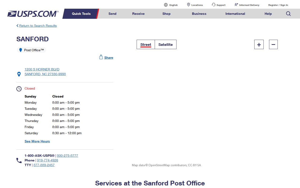
The retail location is useful for a current service question, but it does not determine which county holds a parcel's deed or tax record. Keep postal service and land-record jurisdiction separate.
Sanford's 2001 ZIP Change
A 2001 USPS Postal Bulletin states that 27332 became the last line for a portion of deliveries that had previously used 27330. This is a historical delivery warning, not evidence that a present address still follows the same assignment. Check the current USPS result for present delivery and use the county-overlap table as the jurisdiction warning.
When working with an older document, label the postal evidence by date. Do not carry a 2001 split into a current parcel result without a new postal lookup. The change can explain a different mailing line on a historical item, but it cannot establish a move, a county change, or a person's connection to an address.
Sanford ZIP Codes and City Lines
A ZIP code boundary is not Sanford's city-limit boundary. The city GIS distinguishes corporate limits and ETJ, while the county parcel map supplies the land and tax context. An address can use Sanford as its postal city while sitting outside the incorporated city or, for 27330 and 27332, outside Lee County. State the kind of geography being used before drawing a conclusion.
- ZIP Code
- A USPS delivery code used to form a mailing address, not a legal city or county boundary.
- ZIP+4
- An added delivery segment that makes postal sorting more specific; it does not identify a parcel owner.
- PO Box ZIP
- A postal designation for box service that may differ from the physical land location.
- Unique ZIP
- A USPS routing pattern for a single institution or similar use; it should not be assumed for a Sanford address.
- Carrier route
- A postal delivery grouping, useful for mail handling but not a substitute for a parcel boundary.
When the ZIP code is only a starting point, keep the postal city, incorporated-city status, and county in separate fields. That makes a Sanford result easier to route and less likely to overstate what the mailing line proves.
Sanford ZIP Codes and ZCTAs
The Census Bureau treats ZIP Codes and ZCTAs differently. A ZCTA is a statistical approximation built from 2020 Census blocks, while a ZIP Code is a USPS delivery construct. ZCTAs can be noncontiguous and can include institutional, unique, or PO-box patterns. Census geography for Sanford city is therefore not interchangeable with the areas labeled 27330, 27331, and 27332.
Sanford city reporting distinguishes the city geography from the three ZCTA areas and gives the city a 2020 land area of about 29.1 square miles. That figure should not be used to draw a ZIP boundary. Use a Census figure for a statistical question, a USPS result for delivery formatting, county GIS for a parcel, and city GIS for municipal status. Combining all four into one unlabeled “Sanford ZIP” result hides the distinction that controls the next search.
Reading a Sanford ZIP Code Result
Keep a small evidence trail for each Sanford ZIP code result: the exact USPS query, returned ZIP, parcel and county, municipal status, source URL, and source date. If USPS and the assessor use different labels, retain both and say which one controls the next action. A postal response governs the delivery line; a parcel identifies the land jurisdiction.
For a boundary street near Chatham, Harnett, or Moore, check that county's tax or deed office before treating a Lee County search as negative. For a PO box, rural route, unique ZIP pattern, or historic document, say that postal service and physical land location may diverge. A simple summary can distinguish the USPS last line, the parcel county, the municipal status, and the record date without listing personal details.
Where a street runs near a city edge, compare corporate limits, ETJ, and the left or right municipal field in the development map. That extra check helps explain why a Sanford postal result and a city-created permit record may not cover the same area. It does not turn a postal result into proof of an address's present use.
Note: Save postal, parcel, municipal, and source-date details together so a later reader can see which geography controlled each decision.